Posts

Showing posts from September, 2014

Stats

3,898 miles, 383.982 gallons of gasoline, avg 10.15 mpg.  (If for some reason you are going to take 99 through the valley, don't! There is a lot of road construction and the roadbed is really rough.)  

Ah! Home

We have arrived. We had lunch at Lombardi's in Petaluma. At least it is cooler. her Highness is happy.

HOT! It was still in the 90's at 8pm!

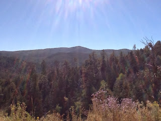
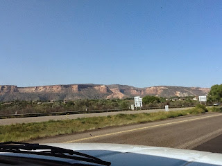
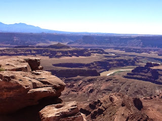
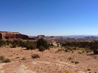
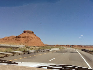
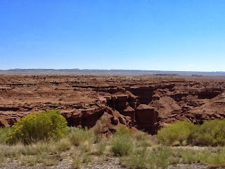
We ended up staying in a Motel 6, cuz it was too hot to sleep in the camper. Ate up over 550 miles on the interstate. The haze was pretty thick when we dropped down out of the high desert into the valley, you couldn't even see the floor. I am always amazed at the size of the wind farms along the way. One blade takes up an entire Oversized trailer, at least 60'. The windmills are spread out on both sides the the valleys, all different sizes. There were even a couple of solar arrays in the mix. Homeward bound!

Wind farm at Mojave CA

Image

1st of the wind farms outside Kingman AZ

Image

Headed home...418 miles

We left Santa Fe with windy conditions and drove through thunder showers. We crossed over the continental divide and gained an hour once we hit Arizona. Got a last fix of 'canyon country' between Albuquerque and Gallup. Got to eat breakfast for lunch at Cracker Barrel in Gallup. It is only 73 here in Williams with an expected low of 47. Everybody should get a good nights sleep. (Her highness is restless when it is hot.)

Museum Hill

We did visit the Indian Art Museum. It was really well done and I was touched with an intensity of feelings for the past abuses these peoples have endured. There was a gallery of portraits done early in the last century that was both beautiful and stoic. Downstairs was an exhibit about tourquoise and how the different tribes shared their artistry with each other. http://www.indianartsandculture.org

Santa Fe NM

We have spent the last couple of days exploring Santa Fe. Yelp came through with a great bakery recommendation, Sage Bakehouse. Downtown is awfully commercial, stuff is either really expensive or over priced imports. I finally got to try a green chili stew...had a bit of a bite to it! Oh...sopapillas and honey...haven't had them since I was a kid in Colorado. It got up to 90 here (but there were reports it was 97 in Oregon and really smoky.) Tomorrow we turn toward home, picking our way through fires and flooded out roads. I am looking forward to eating at Cracker Barrel along the way, my favorite chain that I discovered on our last big trip.

Santa Fe New Mexico

After a leisurely drive over the 'High Road' between Taos and Santa Fe we are relaxing in a sweet rv park on the outskirts of Santa Fe. We are here until Sunday morning. I have researched the thrift shops, with a local pin pointing their locations for me. It was 80 degrees earlier, but our site has a nice breeze so we should sleep well. There were many galleries and shops along our way today. I found my souvenir t-shirt, two ravens artistically done with a couple of spirals in the background. The eye candy abounds everywhere. Tomorrow we may visit 'Museum Hill' and check out folk and Indian arts.

More High Road vista

Image

View from Truchas NM

Image

Crystal clear day on the High Road

Image

High Road to Santa Fe

Image

Enchanted Circle

We traveled the 'scenic enchanted circle today and had we not just toured the western slope of the Rockies, I am sure we would have been more impressed. We topped out at 9101' and visited the Taos Pueblo, a UNESCO historical site. I was reminded of the older homes I visited in Ukraine. Tomorrow we head to Santa Fe on the 'High Road.' It stayed cloudy all day, but no rain. As for the Viet Nam Veterans Memorial, it was built by the father of a soldier killed in action. The property had originally been purchased to establish a resort.

Outside of chapel.

Image

Chapel

Image

Viet Nam Veterans Memorial, Angel Fire NM

Image

Memorial

Image

Earth Ship Housing

Image
From the website.  http://www.sangres.com/newmexico/taos/earthship.htm#.VBeKRWK9KSM Just west of the  Taos Gorge Bridge  is what I call the "Earthship Landing Zone." This is a subdivision composed only of earthships, a type of alternative housing that incorporates  car tires  packed with dirt into the construction of the outer walls. Most of  the house  is bermed into the ground with only the southern walls exposed, allowing for passive  solar heating  and light. It's a very effective method of building in a desert setting, as long as  the car  tires are suitably sealed and the home is properly vented (with this southern exposure they can get too hot if not vented properly). At the eastern end of the subdivision is a  sample /model earthship that you can go into and learn about how they are built and what they have to offer. Imagine: a completely self-sufficient, self-sustaining home with zero utility bills. You'll notice in these photos that a lot of the windows are

Taos!

I finally made it to Taos New Mexico! We started out in Moab Utah retracing our steps to Mesa Verde. Earlier we decided to explore Colorado because of the heat and heavy rains last week. Once past Durango CO we turned south toward Taos. We had lunch in Pagosa Springs Co, shortly after that we crossed the Continental Divide. Our highest point was 10,554. There were lots of hunting camps set up along the way. On East 64 there were a couple of oddities I will check out the next time I am online. There were many old RV's parked in what could be ranchette sized lots. Another odd site was what looked like a 'sea ranch' development of alternatively built homes. Some were partially underground, others with odd shaped turrets and roof lines. One under construction, looked like the walls were being made of stacked old tires. We crossed the Rio Grande Gorge. Tomorrow we explore Taos and drive the 'Enchanted Circle.'

Rainbow outside Taos NM

Image

Wilson Arch, hwy 191, Utah, headed to Taos NM

Image

Cowboy Camp

Cowboy Camp is a typical BLM dry camp. It is small with only 7 designated sites with fire rings and tables. There is a open air latrine that is fenced. On occupied sign hangs from a chain you can hang across the opening. The scenery is amazing, changing minute by minute with the movement of the sun. Rock formations highlighted one minute, in shadow the next. I am familiar with the artists dilemma of many shades of green, and want to apply that to the many shades of red present in the rock formations. As for the flora and fauna we have seen ravens by day and bats at dusk. There are miscellaneous insects among the many blooming plants. We are treated to spring like color I am sure due to the recent rains.

Top of the World.

Image

We are having a leftover feast! Desert Bistro bounty.

Image

Home sweet home BLM Cowboy Camp

Image

9/11/14 Moab Utah

We started out at 6000 ft on the Western Slope of the Rockies to the high desert at 4000 ft. Cruising on I70 when we took a 'scenic byway' on Utah Hwy 128. There were prairie dogs along the way seemingly as curious about us as we were watching them. We drove along the Colorado River Recreation Area where you could tell the road had recently flooded in spots with red dirt. By the looks of things it was a good thing we went farther into Colorado than heading down to New Mexico. There were a number of rafters in the muddy fast flowing river. We saw some cleaning up after. It is already 10 degrees cooler at 7:30pm tonight than it was a week ago. We will head over to Dead Horse Point tomorrow frost thing and see if we can get a campsite for the week-end. I just love this country with the red cliffs and canyons everywhere you look. If you are headed for Moab, We highly recommend the Desert Bistro. We had an excellent dinner tonight. http://desertbistro.com/Desert_Bist

Pretty impressive from any angle!

Image

This is the same river we were looking down on a week ago.

Image

Definitely Scenic!

Image

Cliff side straight up

Image

Colorado River hwy 128

Image

Utah prairie dog.

Image

Leaving the Rockies, headed back to Utah.

Image

The last few days

We have spent at Crawford State Park in Colorado. It has rained, with some lightening and thunder. Today was warm with white puffy clouds. The park is in a valley at 6000 feet above sea level surrounded by mountain peaks and unique rock formations. Tomorrow we are headed back toward Moab Utah. Hopefully it has cooled down some and we can spend a few days at the campground at Dead Horse Point in Canyonlands National Park. Because of weather we are going to head north toward Oregon rather than south to Arizona.

No household garbage?

Image

Crawford State Park, Colorado

Image

Weather in the distance. The rain has been following us.

Image

Morrow Point Lake, Black Canyon North Rim

Image

Our current route

Image

Colorado Mule Deer Bucks

Image

Black Canyon of the Gunnison

Image

Red Mountain Mine above Silverton 11,018 ft

Image

Silverton CO

Image

Coming down from 10,990' on the way to Silverton

Image

Moon over Durango

Image

Staying in Colorado

Spent the day in Durango, hanging out at the Animus river. I am still marveling at all the green grass and running water. There have been light rain showers and the temperature can drop 20 degrees. We are headed to Silverton tomorrow. Plenty of RV parks and other campgrounds to choose from. All my planning was for New Mexico and Arizona, so I have had a lot of homework to do. It feels really good to be in the mountains again.

Friday in Durango

Spent the day exploring Durango. Started with coffee at Durango Joe's, visited several thrift shops, had lunch along the Animas River, bought some groceries and went to a meeting. All is well in our world! Her 'highness' is doing well and loves all the green grass.

9/5...'Mesa Verde'

We spent the day exploring the park, beautiful views and amazing history. We have decided to stay in the mountains for awhile because it is too hot in the desert. I am currently looking for the 'perfect' campsite to spend a few days. Tonight it is Alpen Rose in Durango. They make pizza to order and. Deliver it to you site!

Cliff palace

Image

Sun house point, across from Cliff Palace

Image

NAvajo Canyon other direction.

Image

Navajo canyon atop Mesa Verde

Image

Dinner.

Image

Day 4 Moab to Cortez

The public park in Moab Utah had green lawns and there were lots of beds of pretty flowers. We set off to explore Dead Horse Point State Park and Arches National Park. On the way there we saw signs of mineral wells on BLM lands. At one overlook you could see potash mining along the Colorado River. There is a movement here to get National Monument Status for the public lands due to expansion of mineral leases. Once we entered 'Colorful Colorado' the roads improved. There were fields of sunflowers under cultivation outside Dove Creek CO. We are spending the night overlooking Mesa Verde and the Sleeping Ute Mountain.

Home Sweet Home Cortez CO, Mesa Verde in the background

Image

Fiery Furnace overlooking Salt Valley.

Image

Devils Garden, Arches National Park

Image

Mining for Potash. (BLM lands)

Image

Dead Horse Pt, Utah...Colorado River.

Image

Dead Horse Point, Utah

Image

Breakfast view.

Image

Amazing Country day 3

We left the bare Nevada desert for the red rock canyons of Utah. The highest pass was 7880'. Off in the distance was Sevier Lake, with the San Francisco mountains in the background. Several irrigated cornfields near Hinkley NV. The speed limit jumped to 80 mph on I70. A JJWD hardware store caught John's attention in Salina UT. The 'gusty winds' signs were accompanied by wind socks. Spent the night in Moab, 99 degrees to the mid 70's at night.

Spotted wolf canyon. I70 at bottom.

Image

Rocks red 2

Image

Red rocks begin

Image